
Overland Track - 7 Day Trek | AUS
- Chase Davidson
- Mar 29, 2019
- 33 min read
Updated: Jun 10, 2024

PROLOGUE:
Tasmania has exceeded all expectations I could have imagined and it all started with one hike. The trek known world wide as the Overland Track has been on my agenda since my friend Chloe in Melbourne had told me about it one time when I was preparing to come to Australia. I didn’t know anything about Tasmania at that time and before the end of the day, I swear I had every hike and waterfall imaginable dotted out on my Maps.Me app. I took an ultimate liking to the island state, and became intrigued with so many of their overnight hikes that were steadily available all over the island. I booked the permits for the Overland Track only two months in to my arrival in Australia, August 2017. The permit cost $200 and yes, it is a steep price to pay for a walk though Mother Nature but trust me, it’s 100% worth every single cent.
I had originally planned to do the hike solo when I bought the permit and selected a start date of February 12, 2019. Between then and now however, I met my good friend Louis De Aubeyzon who also worked on the blueberry farm with me in Corindi Beach, NSW. I convinced him to buy into the hike with me and we had planned to move to Tasmania to finish our farm work needed for the 2nd year working holiday visa application. At first, we sort of committed to work until the end of February which meant having to move the start date back until March 1st, 2019.


Turns out, we both lost our jobs at the beginning of February due to a slow blueberry season and I ended up finding a job at Pumphouse Point thanks to one of my mates I had met back in Canada. The wilderness retreat just so happened to be located on Lake St. Clair which is the ending of the Overland Track. I was offered a months work since one of the regular housekeepers had broken her foot. This allowed me to save some money, live on site and plan out our 7-day adventure to come.
Chapter 1: Cradle Mountain
Since Louis had found another job up in Devonport, we planned it out for him to drive down to me a day before we would have to drive up to Cradle Mountain where the official track begins. Louis arrived at Pumphouse Point on February 28th, and it was the first time I got to show him the itinerary for the hike we were about to begin the very next day. After getting all the gear packed and loaded into his car I was able to show him around the retreat a little bit. We opted to have one last big meal before getting some sleep for what would be a very long day.


*During the booking season of October 31 - May 1, people are only allowed to walk the Overland Track if they book a ticket and walk the track from north to south. This meant that you must check-in at the beginning of your hike and also have purchased a national park pass.
We set alarms the next morning for 6:30am that way we could get in a good breakfast before the three hour drive to Cradle Mountain. Scrambled egg sandwiches were on the menu in order to get our carbs up for a long days hike. It was about 7:30am when we hit the road, packed the mate and began to get excited about how the next seven days would unfold. The sky was perfect and the temperature was increasing throughout the morning as it eventually reached record breaking heat for the month of March by mid-day.
Making good time on the drive up and arriving at the Cradle Mountain Visitor Centre around 11:15am we hoped to be on the trail by noon. The introduction while we registered was quite long and the safety speech seemed like it was never going to end. This could have been either due to the fact that we were both so anxious to get going or the fact that I knew the itinerary pretty much inside and out by this point. Nonetheless, you can NEVER be too safe!

Once we had our Overland Track passes (#25/#26), we grabbed our bags from the car, locked up and proceeded to the water station to fill up. I went with 3/4 chilled water and since it was on tap, I added some sparkling water to the mix. This seemed like a luxurious choice at the moment that I later regretted. The shuttle bus had just rolled up to get us to Ronny Creek which would be the drop off point for the track. The bus driver did an excellent job of describing the Cradle Mountain - Lake St. Clair National Park and the whole bus load gave us a warm goodbye and cheered us on as we exited the vehicle.
This was it. The very start of the adventure! We set off along the flat boardwalk from Ronny Creek and before long we had entered into the forest where we encountered a small waterfall known as Crater Falls. It seemed like we made it there in no time at all… Must be because it was only day one. My love for waterfalls is truly remarkable so couldn’t have thought of a better first attraction. The elevation began to climb steadily from this point as we worked towards Marion’s Lookout. Many people believe that day one tends to be the hardest day of the seven due to the steep elevation increase at the beginning, but if you’re prepared and have lots of energy, it’s not too bad at all.


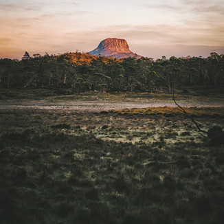
There was one section that had some chains one could use for help but not necessary. This section wasn’t too far ahead of Marion’s Lookout either, so if you find yourself here, you don’t have too much further to go. The views really began to open up from this point onwards. Crater Lake came into full view and before long we were standing atop Marion’s Lookout looking down at Dove Lake completely towered by Cradle Mountain. This marked the first point of the hike that we were able to clearly see the mountain. It was this moment that Louis and I decided it would be best to send it to the summit today while the weather was perfect albeit extremely hot.


The path towards Kitchen Hut from Marion’s Lookout was a breeze compared to what we just ascended and knowing there would be no more steep sections quite like that for the remainder of the trek was a good weight off the shoulders already. We arrived at Kitchen Hut around 2pm (14:00), unclipped from our heavy overnight bags and got together a quick little day bag that would be ideal for the summit. I had ordered a nice light waterproof day backpack but unfortunately it didn’t come in time for the Overland Track. This meant I resulted to a somewhat heavy Reebok bag that looked like it was from the 90’s.
My main snacks for this entire trip consisted of Mega Nut Chocolate Bars and Beef Noodles. I portioned enough that I would be able to eat one of each a day or two chocolate bars a day plus our dehydrated Backcountry Cuisine dinners that we had packed (one for each evening). Feeling like I was going to need some energy to make it up to the summit of Cradle Mountain (1,545m), I decided to eat my first chocolate bar and then pack another for the summit.


Kitchen Hut was located right at the base of Cradle Mountain and the estimated time of return was a mere two hours. At this point we were on our way up and looking forward to the views that would accompany it on such a gorgeous day. The heat was surely getting to us but we had enough water not to worry. The hike itself ended up being a lot more fun than I thought it was going to be. Not that hiking in itself isn’t fun, but I did not expect the scramble that was ahead of us in order to reach the summit. Using both our hands and our feet we were able to reach the summit in about an hour, have a bit of a snack then head on back down to the Kitchen Hut.

Once we gathered all our gear together at the hut, we met a few of the people who were also on day one of the Overland Track. We introduced ourselves and then headed on towards the mountain in the distance known as Barn Bluff. A couple of the French guys would be hiking up that before the day was done but we were happy with doing just Cradle Mountain since we had a long drive in the morning. The pathway from Kitchen Hut was a lot easier to walk along and void of any steep terrain but we were still quite far from the Waterfall Valley campsite which was located at the base of Barn Bluff. It was during this push where the feeling of actually being on a multi-day hike began to set in. We were no longer around people on day hikes and completely alone out in the “middle of nowhere”.
There was a helicopter at one point that frequently passed by overhead as it delivered goods and materials from location to location but besides that, we were met with the sounds of nature throughout the evening walk. We came closer to the campsite around 7pm (19:00) as the sun began to set beyond Barn Bluff. What an amazing sight to behold on our first day out. Once we arrived at the Waterfall Valley campsite, we had a short time to figure out how to set up the new tent I had purchased, cook some dinner and then get to sleep in order to have as much energy as possible for the next day’s adventure.


The meal of the night was Classic Beef Curry and boy did it warm our stomachs up nicely. Knowing the sky was also going to be crystal clear this evening, I decided to lay down for a bit before getting some final shots of the stars over top of our campsite. Timing was perfect with another camper going to sleep and lighting up the inside of her tent. Thank you and goodnight!
Chapter 2: Lake Will & Frog Flats
During the night we had a few possums fighting it out in the nearby tree and if you’ve ever heard possums fighting… It’s like the sound you’d expect the devil to be making while getting attacked. Needless to say, we managed to get some sleep and woke up just as the morning sun shined it’s rays across Barn Bluff. A truly magical sight to behold! Since we had forgotten our coffee in the car, we had no reason to stick around the campsite. A quick brush of the teeth, use of the composting toilet facility and we were on our way to Lake Will.


The morning’s walk was so much more chill than the previous morning. Mainly boardwalk and some natural terrain but with zero elevation gain or loss had us approaching the junction at Lake Holmes in about an hours time. There was a guided group ditching their big bags for day packs at this point. We were about to do the same. The main thing we had to be careful about when ditching the overnight bags is that we close up all our zippers and cover the sacks in the rain cover. This was obviously to protect it in case of a rain shower but more importantly to prevent the birds that have cleverly learned to open zippers over the years. Trust me, you don’t want all your food disappearing on the second day of a seven day hike!

Lake Will was only a 30-minute walk from the junction and having the heavy weight off the back made it a breeze. Mind you, I was the one typically carrying the day pack which consisted of my camera setup, 2L of water and some snacks for both Louis and I. Light but not featherlight. We caught up with the guided group ahead of us on a beautifully sanded beach on the shore of the lake, but we didn’t want to intrude or be with a huge group of people while we’re escaping just that by coming on the Overland Track.

I had asked the guide about Innes Falls which was supposably just a short while further down the path because I couldn’t see where the path continued. Quite confused the guide answered me explaining that it isn’t topographically possible for a waterfall to exist at such a place. Was my research of this waterfall false?
Stubborn as I am, I opted to search for the track myself and although it wasn’t quite an easy route to follow we were able to make way throughout a trail (possibly a wombat trail) that meandered the lakeside and eventually led to Innes Falls. There was moments on this trail that felt like we were simply just bushwhacking but using my trusty Maps.Me app and my navigation skills, we were able to stay on track, avoid stepping on any unfriendly critters and have a glorious spot to relax for a snack.


Louis got to soak his feet in the river running to the falls while I enjoyed my first noodle packet of the trip. We knew we still had a bit of a distance to go and wanted to enjoy the beach we had met the guided group at for a little bit as well. When we arrived back at the beach, it was all to ourselves. The water was cold but refreshing to say the least. I walked around for a bit up to my knees and dunked my head in a few times before we made our way back to our overnight bags at the junction.
It was still pretty early in the day at this point and judging by the map, we only had a couple hours to go before we made it to the next campsite of the trip, Lake Windermere. While walking towards that destination, we thru around the idea of possibly pushing on to the next campsite which was located at the lowest point of the Overland Track. That would allow us to take advantage of the sunny weather today and set us up greatly for tomorrow’s hike. As it got closer to 12 noon, the temperature began to heat up like the day prior. We kept a steady pace and enjoyed the overwhelming views of the surrounding mountains.


This part of the track was when we got to fully witness Mt. Ossa for the first time. Standing at an elevation of 1,617m is Tasmania’s highest mountain and we are fully committed to making that summit possible in just a couple days time. Getting to see it so far in the distance sort of makes it a bit surreal knowing how much ground still needs to be covered before you even think about beginning the ascent.


Around 2:30pm (14:30) we found ourselves at the shores of Lake Windermere and knew we’d be making a big push this afternoon for the next campsite, Frog Flats. Louis needed to catch a bit of a rest before then and given the location, it seemed like the perfect place to do so. He rolled out his sleeping mat and caught a 45 minute snooze while I soaked my feet in the lake and analyzed what was ahead of us.
I estimated we had about nine more kilometres to go but the itinerary was stating it was mostly downhill after the Lake Windermere campsite. We departed shortly after 3pm (15:00) in the deadly afternoon sun as we crossed the Pine Forest Moor. This open area is fully exposed and we were using up most of the water we had filled our packs with. Looking around at the dried up lake beds made you get the sense finding water wouldn’t be so easy. Much of the beginning also happened to be up hill without much down but that would change once we arrived at the Forth Valley Lookout.


It was a bit of a relief when we arrived at the small junction showing us the 1-minute detour to the lookout. We knew at this point we halfway to Frog Flats and were entering into a rainforest that would offer us shade and hopefully water. It would also be a gradual descent down to our campsite. Don’t think twice about going to the lookout either! It’s literally 30 seconds and the view is phenomenal.


The highlight of the day came during the descent when two wombats were chilling on the trail. What seemed to be the mother and baby, they took their time moving allowing us to take some photos before continuing on. This is when we were met with what could have been an issue for some. The whole idea of the rainforest having water… Not so much. Due to the extreme heat over the past week all the rivers had dried up and there was no running water to be found. I had a quarter of a litre left and Louis had about the same. That was enough for us to cook our dinner but we’d have no water to wash it down with. I began to keep a stern lookout at each possible water supply we passed and eventually found one that had a very very slight trickle of water but it was enough to get about a litre of water in my water reservoir.
*I use a makeshift built-in water filter on my line made by Sawyer that filters out any bacteria allowing me to drink from nearly any water source.

We arrived at the bottom of the Overland Track at 8pm (20:00) with barely anytime to spare before darkness. Louis had got the water boiling for the dinner (spaghetti bolognese) as I quickly set up the tent in a suitable area, had perhaps the fastest dinner of the trip and quickly went to sleep completely exhausted from covering over 22km this day.
Chapter 3: Pelion Hut & Mt. Oakleigh
Thankfully our decision to take advantage of yesterdays beautiful weather was already paying off as we awoke in the morning. The rainforest cover above us blocked much of the rain that had fallen overnight and you could feel the moisture in the air. Before beginning the trek, I had one opportunity to look at the estimated weather forecast and this day in particular had called for overcast skies with a chance of rain. By knocking off the additional nine kilometres yesterday afternoon, that saved us a non-enjoyable muddy walk down through the rainforest.

Once we packed our tent up and got the gear on our backs we made way for the next hut, Pelion. It wasn’t long before we exited from the rainforest and were excited to see how much ground we actually covered while we were blinded by the large trees surrounding us. With West Pelion looming overtop of us to our right, I got the feeling the day’s walk would be quite a bit shorter than expected.


What felt about an hour since we departed from Frog Flats, we came to the junction leading out to the Old Pelion Hut which the supervisor of the old mines would use. This was about a kilometre off the main Overland Track but I would highly suggest checking it out and read up on the history of the area with the journals inside the old hut. There is also a swimming hole not far away that would be ideal on those hot days like we had earlier in the hike.


However, it was beginning to rain again and we only partially covered our main bags when we set them down so we needed to double back. On the way we came across the cutest little echidna just off the boardwalk. It was making the softest puffing noises as it wobbled along coming closer and closer to me. Adorable! With only ten minutes to go until we made it to the New Pelion Hut where we’d be staying for the night we became excited by the thought of a warm noodle soup for lunch. As we came upon the hut, there was two hikers heading out towards the Pelion Gap. We had the entire hut to ourselves at this point and contemplated wether or not we should push on or stay put in order to rest up for a big day tomorrow. After warming up with our freshly cooked noodles, we decided it would be best to stay and rest. At this moment, Louis noticed my head was bleeding and we couldn’t figure out what caused it until we noticed a leech drop out of my hat and onto the ground. Damn blood sucker!


Since it was currently pissing down rain outside, we thought it’d be a nice change to stay in the hut instead of having to set up the tent and risk getting it all wet. First come, first serve is the basis when it comes to the huts and we were the front runners. We grabbed two floor bunks next to the window and began setting up for the night. The local gentleman who helps maintain the hut had told us about Mt. Oakleigh which we could see in the distance. He mentioned it’s definitely worth doing if we planned on sticking around for the day and the weather wouldn’t effect the route up at all. That was enough to convince Louis and I that we would in fact not be having a chill day after all.
Once we had everything all set up for the night, we packed our day bag and off we went. Estimated to be about a five hour return hike, our fingers were crossed that it wasn’t going to rain any harder than it had been throughout the morning. Crossing the plains was simple and there was a couple of fun little bridges that added nicely to it. It wasn’t long after we entered the forest lining the bottom of the mountain and we began the steep ascent towards the summit. The trees became thicker and at one point we felt as though we were in an entirely different country altogether.


Eventually we came upon our first lookout after smashing our way up and wow, the view out over the valley was breathtaking. There was still more to climb and it didn’t seem as though the weather would be getting any better. Continuing up and breaking out of the trees came an intense and chilly wind. We had to put all the layers we had brought with us on at this point but it was worth it completely. Once on the top, we had to traverse across to the spires on the west end of the mountain and from there we could see a full 360 degrees around. The dolomite peaks poking up from all directions was incredible. There were moments when the rain would hold off for some photos but before long it would begin again, sometimes even by means of hail.


On the descent down, the sun began to peak through and by the time we exited from the forest below, it was like a new day altogether. A beautiful blue sky and the hut was entirely packed by everyone who had been coming from the Lake Windermere campsite. It was only 5pm (17:00) at this time so even after a summit hike, we’d still be able to get a good rest in. This proved to be a good time to recharge everything we needed to and cook up an early dinner. On the menu tonight was Lamb Roast. Yum!


As we were all getting ready for bed, the man maintaining the hut had let us know that the weather was looking excellent for tomorrow with no signs of rain. Here we come Mt. Ossa!
Chapter 4: Mt. Ossa & Kia Ora Falls
A couple of the lads who shared the room with us last night woke up at 4am in order to get up Mt. Ossa for sunrise. Louis and I however were not so eager and slept in till 7am. This still gave us plenty of time to wake up, have a coffee… Yes, coffee! While I was out shooting the sunset the evening prior on the nearby helicopter pad, I had mentioned to one of the guys I met that the one thing missing was coffee. He graciously said he had brought more than enough and gave me four small single packets. That either meant a coffee a day for me or two coffees between Louis and I. You know I had to go with the latter on that one!

After our first morning coffee it was time to head towards Pelion Gap. This is the gap between Pelion East and Mt. Doris / Mt. Ossa. It’s roughly 350 metres higher than the Pelion Hut which makes it one of the steepest ascents since day one. Just before the track begins to climb however there was a cut off to a couple smaller waterfalls which left us completely alone for a bit. Not sure if many people go to these two but it’s certainly worth the two minute walk off the Overland Track.


Then the climb began and it sure was a haul and a half. I prefer these types of climbs typically because the reward comes sooner than you’d expect. Mind you, having a 20kg bag on your back doesn’t make it easy, using the Black Diamond pole I had brought with me certainly helped the matter. Within an hour we had made it to Pelion Gap. I had rationed my food intake so I would have an extra chocolate bar this day specifically for conquering Mt. Ossa. Louis and I both had a snack at the gap and switched over to the day bag. Estimated to be about a five hour return, we didn’t want to waste too much time lolly gagging around and just went for it.


The beginning of the track heading up was all man made which made it extremely easy not having to watch your step or worrying about twisting an ankle. It wasn’t long until we were just below the summit of Mt. Doris. This was funny to me because my mom’s name is actually Doris and I never thought in a million years that I would come across a mountain with her name attached to it. This one is certainly for you mom! We also ended up crossing paths with Jordan and Mark, the two guys who slept in our room and left for sunrise in the wee hours of the morning.
As we got around to the saddle between Mt. Doris and Mt. Ossa, we could tell that the path was going to become quite a bit more difficult. Eventually it came to the point similar to Cradle Mountain where we’d be scrambling up using both our feet and hands for points of contact. Getting closer and closer to the summit became increasingly difficult and there was one section we basically had to climb near vertical in order to get up. That’s what I’m talking about!


Just a bit more scrambling after that and we found ourselves on top of the highest mountain in Tasmania. A full 360 degree view in every direction is exactly what we were looking for and what a beautiful day to get it done. We spent quite a bit of time on top of this one. I got into my second of three chocolate bars for the day and just enjoyed the views as much as possible.


At one point we had thought of racing down and then going up East Pelion to make it four summits in four days but during the descent we both felt a tad bit exhausted and were more excited about getting to the next camp which supposably had a waterfall we could take a dip in. Once we made it back down to the Pelion Gap and looked up at East Pelion, we knew there was no way we were going to go up. Using the gap as another excuse for a chocolate bar, I stuffed my face before loading up the hiking bag and continuing on towards Kia Ora campsite.
I had read on the PDF file I had taken with me that it would be only an hours walk from the Pelion Gap to the campsite but it turned out to be closer to two hours. Maybe my pace had slowed quite a bit from hiking Mt. Ossa or maybe I’m just not up to an average hikers standards. Either way, we made excellent time and arrived at the campsite by 5pm (17:00). As I was getting the tent all set up for an epic back drop, a couple of hikers came in really late and demanded us to move our tent and make room. I wasn’t having their attitude and gave back perhaps a little myself but opted to move the tent after we got a couple photos. The one girl who wasn’t so abrupt with telling me what to do came back a bit later and said don’t worry about it after all. Louis and I ended up still relocating the tent a bit in case anyone else showed up a bit later but we ended up having the whole pad to ourselves in the end.

Once all the drama was done, it was time to get wet. Louis ended up going with two other French guys who were doing the Overland Track to a small little river and I went down by myself to the Kia Ora waterfall. The water was certainly cold but it was worth the dip. A beautiful waterfall swim that you’d be crazy to resist. I spent some time down there as others came for a bit of a skinny dip and then headed off to meet back up with Louis for dinner. Tonight we would be having Thai Chicken Curry - Hands down my favourite of the whole hike! Whoa, so good!
Knowing tomorrow was going to be an insane push if we wanted to go to what’s known as The Labyrinth, I tucked myself into my sleeping bag by 7:30pm (19:30). I told Louis at this point to be ready for a 7:30am start because we had over 10 hours of walking ahead of us and within a few minutes I heard him getting into his sleeping bag as well.
Chapter 5: Waterfalls & Pine Valley Hut
Today would be our earliest start to a day and for good reason. I never got to explain to Louis what we’d have to do the night before but during the morning’s leisurely beginning I was able to express just how many kilometres we’d have to cover - Nearly 25 kilometres. The reasoning for this was simple. We heard from a couple travellers while we were on a road trip through the southeastern mainland that The Labyrinth was not too be missed. That sounds like no problem, except the fact that The Labyrinth just so happens to be located near Pine Valley Hut which is almost 5km off the Overland Track and is still an extra three hours roundtrip from that hut as well.


Not long after leaving the Kia Ora campsite we arrived at the Du Cane Hut which was a historic hut with some history such as the Old Pelion Hut we visited earlier. We didn’t plan to spend too much time at this one and really only needed to use the toilet. This toilet was not quite what I expected after seeing the typical toilets at the other huts.
There was a sign at this hut saying the Windy Ridge Hut was only three hours away at this point. That would be the hut we bypass in order to take advantage of the full day. What this sign doesn’t say though, is that there is three amazing waterfalls on the way, just a bit off the main Overland Track. Within about 45 minutes of leaving Du Cane Hut, you’ll come upon a junction with a sign leading down to two waterfalls, both equally impressive.


Depending which way you decide to go at the split, you can either see D’Alton Falls or Fergusson Falls first. We went with the latter thinking the right way is the right way. The thunderous roar of a giant waterfall caught our ears and the excitement began to build. Yes, we saw a few waterfalls already since day one but I knew these ones were going to put those little ones to shame. Fergusson Falls set the bar the moment we set our eyes on it. Powerfully coming off the cliff above us and crashing into the river below was incredible and we knew that there was no way we’d be able to swim in this one. We spent a little bit of time here and than backtracked to the split and off to D’Alton Falls.
D’Alton Falls was without a doubt my favourite of all the waterfalls we’d seen so far. The way it cascaded down the cliffs and than took a horseshoe type bend at the bottom was magnificent. My shutter on the camera couldn’t get enough action. These two waterfalls, including the trek down took about an hour and a half to fully acknowledge. As we got back up to the main track, the others were starting to catch up to us. The early morning plan had worked great so far, leaving just Louis and I basically alone with the waterfalls.


We scooted down the Overland Track for another 30 minutes before another junction stating Hartnett Falls was in front of us. This one was a bit further off the main track but the highlight of this one would have been the fact that you get to see it from not only the top, but can navigate down to the river below for a swim near the falls. Of course, we had to do both! A few minutes into the hike down, I realized I forgot my tripod… If anyone knows about shooting photos of a waterfall, a tripod is a must. I ran back to my bag like a trail runner and than quickly caught back up to Louis. My energy levels were high this morning because of all these waterfalls. We opted out of seeing the falls from the top and went straight to the bottom hoping to get there before anyone else showed up.


Are we selfish? Or are we clever?
The water was freezing just like all the other times but I needed to get my feet wet in order to get some shots I’d be happy with. Just as I was finishing up my photos, some of the other hikers began to show up and one girl jumped into the water like it was nothing. Couldn’t believe it and I just had to applaud her. Now that we had seen the waterfall from the bottom, it was time to get up on top.

By the time we returned to our bags on the main track, the guided group we had met a couple days prior at the beach on Lake Will were getting ready to go down to the falls. I chatted with the guide for a bit about the waterfall that she didn’t know about and she was still dumbfounded about how it was even possible. Nature works in mysterious ways some times! She gave us some great intel about the trees and had us even tasting different leaves. Not a bad trade off I’d say.
The rest of the trail to Windy Ridge campsite seemed a lot longer than it was. It may have been due to the fact that in my head I knew we had so much longer to continue afterwards. The main topic of conversation throughout this entire journey has been food. From day two onwards, no matter what we talked about, food would come up. We were desperately craving some real food by this point. A burger seemed to be the consensus but it would have to wait a few more days.


When we eventually arrived at the Windy Ridge campsite, we boiled some water and had a delicious gourmet… bag of noodles. This was pretty much as gourmet as it got on this journey aside from out Backcountry Cuisine dinners. This newly renovated hut use to be the home of Bert Nichols, one of the pioneers of the Overland Track. The interior was equipped with a bunch of interesting reads that made for some good reading while we enjoyed the warmth for one last evening.
Once our bellies were full and energy levels were about as high as we could get them, we headed back onto the Overland Track in the direction of Narcissus Hut. Typically while doing the Overland Track, you’d go from Windy Ridge to Narcissus Hut on either the second last or last day depending on whether or not you’d be taking the ferry to Cynthia Bay.
*The ferry (booked in advance) covers the 19km stretch between Narcissus Hut and Cynthia Bay, therefore eliminating a day’s walk. Many hikers will opt to do this method if short on time or are ready to complete the “new” Overland Track. The original Overland Track is fully complete by walking the 19km’s which is what Louis and I had planned to do.
Fun fact: The term “Overland” was first introduced when the ferry system was introduced. It was used to describe the initial part of the track that is ironically “overland” and then bushwalkers could use the ferry to cover the Lake St. Clair section of the track. At this point the original length of the track had been semi-forgotten as many hikers would begin to opt for the ferry back to Cynthia Bay.

It was only about an hour after leaving Windy Ridge when we could tell that we’d be battling the weather shortly. Dark clouds began to roll in behind us and through the valley. We had one moment of bliss in the glacial valley with the ground reminding me of my trip to Iceland. It was as though I was standing on moss covered volcanic soil, soft and springy. After six days of hiking, we finally got to see a couple of tiger snakes and not just any tiger snakes, the biggest ones I’ve seen since coming to Tasmania. Thirty minutes later we were halfway between Windy Ridge and Narcissus Hut, the junction to Pine Valley Hut. From here we would then be going up hill for nearly five kilometres.


A trickle of showers began to come in from time to time reminding us that we were in a bit of a race against time. Knowing that the sky could downpour at any moment, we tried to keep our pace up but due to the fact we’ve been walking all day, I was running increasingly low on energy. A couple of suspension bridges along the way got my blood rushing with excitement but otherwise I kept checking my Maps.Me app hoping to see our location become closer and closer to the Pine Valley Hut. We still had about 30 minutes to go and it was almost 7pm (19:00). We pushed as hard as we could possibly go for the last time and made it in just under 20 minutes, beating the onslaught of rain by mere minutes.

It was so refreshing to get inside the Pine Valley Hut, set up our sleeping arrangement for the night and then cook a well deserved dinner. With only two nights ahead of us, we saved what we thought would be the two best Backcountry Cuisine meals, beef teriyaki and honey soy chicken. Honey soy chicken was the optimal choice for this frigid night. We weren’t alone here and we actually met up with the two French guys we met on the first day of the hike. They had been cruising through doing as many mountains as possible. Guess when you have the Alps as your backyard, these little Tasmanian mountains seem like a kids playground.
After catching up with everyone, it was time to call it a night. We knew the weather was going to be the worst of the trip come the morning but we still had our minds set on seeing The Labyrinth, even if the visibility was at a low. Originally, we wanted to hike up the nearby mountain called The Acropolis but knowing how bad the weather was going to be it became more of an after thought.
Chapter 6: The Labyrinth
It was the coldest morning yet, and the rain was coming down in buckets as we looked out the window. We had saved two single packets of coffee for this day especially. Even with a hot energized drink to start the day, it would not save us from the cold ahead. We got bundled up as best we could. I decided to go with my Coalatree adventure pants, a thermal long sleeve, a long sleeve and my rain jacket… Why I didn’t wear my rain pants is beyond me. I knew we’d be getting soaked on the mornings hike to The Labyrinth so I made sure to keep a warm pair of wool socks waiting for me when I returned.

We waited on the porch of the hut for a few minutes until the rain let up a bit and then went for it. The elevation to The Labyrinth kicked in almost immediately. Due to the increase in elevation so quickly, the rain had begun to transform into giant snowflakes. Not enough to stick on the ground but enough to feel as though you were in some kind of magic land. The path shot up a river stream where we needed to watch each step hoping to avoid getting our feet drenched at the start of a three hour venture. The trees became denser and before we even made it to the clearing, we were completely soaked from head to toe. Wet but still warm due to the exercise we were getting, the only thing we could do was continue to push on. There was no way we were going to turn back at this point.


When we finally broke out of the trees, it was as if we entered a whole new chapter. A winter wonderland. A sign that we soon would be heading back to Thredbo for another winter snow season here in Australia. The excitement of this much snow made me forget about the cold. We just kept moving towards our destination skipping across the stones. We came across a gentleman named Simon who was waiting for his wife to catch up. They had been traversing from the other side of the mountain and planned to sleep at the Pine Valley Hut tonight. We kept it short knowing we’d be seeing each other again sooner rather than later and continued on. The two French guys from day one had gotten a head start before us and one of them was on his way back shivering and in hurry to get back to the warm hut. His friend Renaud wasn’t too far behind and he let us know that Cyane Lake was just a bit further ahead. At that exact moment, the winds began to pick up and the snow then became a blizzard pounding against our skin.
The rocks and stones we had been using to avoid the puddles now lied underneath the water. There was no more avoiding the inevitable. It was full on trenching by this point. Luckily, it wasn’t long before we reached the lake. The sun actually poked through for just a minute or two but it was enough time to get a few shots in before the blizzard came around for round 2. Shivering and cold, we had to get a move on again. Standing around admiring the scene is one thing but the temperature at that elevation was enough to deter anyone from sticking around.

Going down was much quicker it felt. We knew the route we had taken up but at times we still had to keep a lookout for the cairns that marked the path. Getting lost in this weather would be devastating. The river stream we had passed earlier was flowing a bit more and the puddles were impossible to skip over. Already feeling the pools of water formed in my boots, I didn’t care about avoiding them at this point anyway.
Once back at the hut, the ones who had stayed behind to out wait the weather had built up a beautiful fire on the wood stove. Getting our wet gear off and hanging was satisfying enough, but getting that final bowl of hot noodles down was the cherry on top. For the next four hours, Louis and I stood around the wood stove holding each piece of clothing up doing our best to dry it off. We pretty much had it all dried out and ready to aside from our socks and boots.
As much as we wanted to stay put inside this comfy hut for the night, we knew we had to push on to Narcissus Hut which was about three hours away. At this point, it would all be downhill and void of any steep sections for the rest of the Overland Track. Making it to Narcissus Hut would set us up for the final 19km on our last day. I still had that warm pair of fresh wool socks to put on and it definitely helped for the first half of our trek.
The rain had dispersed quite a bit but left an annoying amount of puddles along the track that we’d have to straddle around, sometimes unable to avoid. We came to the original junction that led us to Pine Valley Hut and looked back at the snow covered mountains we just left. It seemed as though we’d be in for sunshine throughout the rest of the day.

The track to Narcissus Hut was pretty uneventful until we reached the Narcissus River crossing. The most beautiful suspension bridge we’d cross on the hike. Not too mention the view behind us of the mountains surrounding the glacial valley. Knowing we were close to the hut was reassuring since it was getting close to 6pm (18:00) but we were quite surprised upon arriving.
Narcissus Hut was completely packed. The groups who had told us they’d be continuing on to the next campground had in fact set up in this hut. What do we do? Do we set up our tent or try and push to the next hut thinking it would be next to empty if everyone is staying here. Louis needed to take a break for a snack and I said I’d keep going since his pace was much quicker than mine. This meant we’d be pushing another 5km (two hours) and arriving around 8pm (20:00). It was a risk I was willing to take!


With the weather on our side for the evening, it couldn’t have been a better choice. About halfway between Narcissus Hut and Echo Point Hut, I was greeted with the first lakeside views of Lake St. Clair. It was this point that Louis ended up catching up to me. We still had an hour to go and didn’t want to waste too much time, even though the view was incredible.


Around quarter to eight we arrived at Echo Point Hut and the sound of silence was surrounding us. Did we just strike gold and get a hut all to ourselves? Not a chance… When we opened the door to the eight person hut, we were greeted with laughs and warm welcomes by not a few people, but by a whole hut full of 13 people to be exact. Louis and I just looked at each other and laughed. Everyone was more than welcome in allowing us to come in, whereas we didn’t even get a hello from the Narcissus Hut. Erik, one of the Germans we had met at the Pine Valley Hut had taken full control of the wood stove, blasting the temperature inside to a beautiful 30 degrees Celsius. It was so hot when we entered that my glasses had completely fogged up.
We got off all our wet gear and found spots around the ceiling, walls and floor to start the drying process. Wherever there was space to fit a piece of clothing, we’d find it. A Dutch girl and an Australian girl made room on their bunk for myself, and Louis took a spot on the floor alongside one of the older gentleman. Sure, we were bit over the limit but we made it as comfy as possible. Aside from the fact that I had a leaky roof dripping on my head all night, this was the most comfiest of sleeps I had. WE ended up playing games together with everyone and telling kids stories to one another.
Word in the hut was that the weather was suppose to be on our side for the next day which meant an easy three hour walk to finish off an enormous seven day trek.
Chapter 7: The Final Push to Cynthia Bay
One by one, we all started waking up throughout the morning. When everyone was lying down, there was more than enough room to move around but as more and more people awoke, the space became a bit compact. Louis worked his way out to the beach for his breakfast and I went out back to the beach on the other side of the hut to enjoy the distant mountains one last time. As today was the last day of the hike, I had two chocolate bars for breakfast and couldn’t be happier.

By 8:30am we all started to stagger out of the hut and begin working our way towards Cynthia Bay. It should only take around three hours at this point but my new boots I had bought for the hike had all of a sudden given me a bad pressure point on my right big toe causing excruciating pain. Thankfully, this was all happening in the final 12 kilometres of the hike but would make our final day a bit longer than expected.
I decided to start using both the walking poles I had brought with me in order to relieve some of the pressure off my foot but nothing would get rid of the pain fully. I told Louis to just keep talking no matter what. Let’s talk about anything, that way my mind would be off the foot. It tended to work for the most part, aside from a few times where I almost toppled over from intense jolts here and there.


One of the questions Louis had asked me was “Where is everyone from that works at Pumphouse Point?”
As I was answering him by stating everyones name and nationality, we heard a call from behind us… “Chase!?” To our ears, it was my friend Matt who happened to work at Pumphouse Point as well. He had taken the ferry to Echo Point Hut in the morning and was working his way back to Cynthia Bay. Talk about perfect timing! We only had about 30 minutes left to go and now we even had a ride back to Pumphouse Point. I could already smell the fresh loaf of sourdough bread cooking in the oven at this point.
The trail was no longer natural, and the walking was as easy as ever. Of course I still had the pain in my foot going on, but knowing how close we were to the end allowed me to just keep on pushing. We came upon a sign that read “Mt. Rufus Summit Track” and at this point it was all familiar ground. I knew we only had five more minutes before we were at the Lake St. Clair Visitor Centre.

There it was. The end to our 7-day adventure through the Tasmanian Wilderness. Matt grabbed a photo of Louis and I together in front of the Overland Track sign, then we de-registered in the book before enjoying a luxurious ride in Matt’s Peugeot 306 back to a warm shower and hot food.
No lie, Louis and I spent over $100 on food this night and honestly just kept eating and eating and eating… That of course included a celebratory drink as well! In the end we covered nearly 140 kilometres, gained over 3,000 metres in elevation and came back with an epic trip we both will never ever forget.

This is Tasmania and this is living!

Comments